Recreation Sites
Ticknock Recreation Site
Ticknock
============================================
Site Name: Ticknock
National Grid Reference: O 152 242 Understanding grid references
Ordnance Survey Ireland Discovery Series: 50
Location
Ticknock is located in the Dublin Mountains, only a half hour 44B bus or car journey's time from the centre of Dublin; 3 km south west of Sandyford.
How do I get there?
From the city centre, head for Marlay Park via Rathfarnham. Passing the main entrance to the Park on your right, turn right at Ballinteer St.Johns Clubhouse and, following the road around the edge of the Park, turn left at the Taylor's Grange junction onto the R113. Take the second turn on the right and this will bring you to the entrance to Ticknock forest.
......................................................................................................
Parking Information
Opening times: 06:00 to 22:00 (6am to 10pm)
Parking fee price: None
Car Spaces: 145
Please use the car park facilties provided and do not block local resident's access along the public road.
Note: When Met Eireann forecast snow/ice condition warnings are in place the car-park may be closed at short notice. In a Met Eireann 'Red' Wind warning, you should not enter any forest area. Updates on car-park and recreation site closures will be posted on the News page.
......................................................................................................
Features:
- National Waymarked Ways Trail Head
- Picnic Site
- Walking Trails
- Mountain biking
- Permanent Orienteering Course
- Viewing Points
- Waymarked Trails
- Historic buildings
Activities:
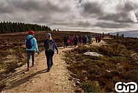
- Walking/Hiking
- Mountain biking
- Orienteering
- Bouldering
Toilets: no toilets on this site.
Site Description
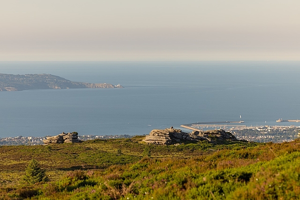
Ticknock offers up to 10 km of mountain and forest walks with some spectacular views of Dublin City, Dublin Bay, Bray Head and Wicklow Mountains. The forest has an extensive network of forest trails with pleasant walks through the plantations of Sitka spruce, Japanese larch, Scots pine, Monterey pine and lodgepole pine.
The entrance to the property at 270 meters above sea level leads to the summit of the Three Rock Mountain (444 meters above sea level). The three large rock formations are the result of weathering and together with picturesque views over the Wicklow mountains and the coast create a very popular tourist destination. In the area, there is also a Two Rock Mountain (536 meters above the sea level) with romantic ruins of the Fairy Castle.
The walking paths in this area are of moderate difficulty. The main forest roads are easily accessible for children and people with lower level of fitness. Ticknock is a possible starting point for the Wicklow Way, many parts of which are strenuous for walking. When taking this yellow waymarked trail and venturing into the hills, visitors are advised to be equipped with waterproof clothing, strong shoes, a drink and a map of compass.
Walking trails in this forest include Fairy Castle Loop, Dublin Mountains Way and Wicklow Way.
The Fairy Castle loop is a lovely looped walk taking in the wonderful views over Dublin from Three Rock Mountain and Fairy Castle, traversing sections of the Dublin Mountains Way and Wicklow Way, before returning via the old rifle range to the car park.
Fairy Castle Loop
Trail start/finish point: Car park
Length: 5.5km Time: 90-120 minutes
Degree of difficulty: Moderate
Metres climb: 210m
Trail waymarking: Green
Ticknock forest offers an easy access to Kilmashogue and Tibradden Mountain.
Recreation sites which you can access from here are:
Kilmashogue
Ticknock Trail(s)
- Fairy Castle Loop (5.5 km / 1 3/4 hr / Moderate) - Green way marker
- Download Map - All Trails
- Ticknock Mountain bike trails
- Coillte Tiknock
- Ticknock Permanent Orienteering Course: Short Course Map
- Ticknock Permanent Orienteering Course: Medium Course Map
- Ticknock Permanent Orienteering Course: Answer Sheets
- Ticknock Permanent Orienteering Course - All Controls Map
Nearby Pit Stops:
For more information on all Coillte's recreational sites visit http://www.coillte.ie/our-forests/explore/
- Recreation
- Archaeology
Recreation Sites in the Dublin Mountains
- 5. Kilmashogue
- 6. Ticknock
- 7. Carrickgollogan
- 8. Barnaslingan
Archaeology Sites in the Dublin Mountains
- 1. Slievethoul
- 2. Lugg Woods
- 3. Seahan
- 4. Hell Fire Club
- 5. Massy's Wood
- 6. Tibradden
- 7. Kilmashogue
- 8. Ticknock
- 9. Ballyedmonduff
- 10. Rathmichael Wood