Recreation Sites

Glenasmole
 |
Site Description
The Glenasmole Valley is home to the Bohernabreena reservoir and waterworks and managed by Dublin City Council. The reservoirs supply approximately 35,000 households in the southern central part of Dublin city. Work began on the reservoirs in the 1880's to serve three objectives: flood control, a supply of drinking water and water for millowners. There are two reservoirs, the upper lake with cleaner water from the lower, non-peaty slopes provides drinking water, while the lower lake contains peaty water from the upper slopes which supplied the numerous mills down the Dodder. The stone faced channel which runs parallel to the upper lake brings water directly to the lower lake. Water is brought to Ballyboden, 7.5km away, for treatment. An impressive overflow system is visible at the upper reservoir.
In 1908 the two lakes were quite bare around the edges. Now, with a mixture of planting and natural colonisation, there are a mixture of larch, Scot's pine, Corsican pine, Douglas fir, hazel, birch, ash and sycamore. Bird species present include gulls, kingfisher, dipper, grey wagtail, heron and moorhen. The main fish species in the lake is trout. Fishing is by permit only which can be obtained from the local angling clubs.
Walking Trail(s)
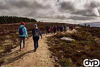
Upper Reservoir Loop is an enjoyable walk along the road which runs parallel to the Dodder. Passing the lower reservoir, the road continues on towards the upper reservoir. Here the walk does a loop around the upper reservoir shores which are clotheed in a mixture of trees and shrubs. Along the western shore of the lake, runs the stone-faced channel bringing peaty water to the lower reservoir. On the eastern shore above the lake lies the historic St. Ann's graveyard. The church (Church of Santan) is thought to have been in use until the mid 16th century. access to the graveyard is by following the DMW yellow markers down to Castlekelly and back along the road to the graveyard. The Upper Reservoir loop trail then continues on around the reserovir and back out the road to the entrance gate and car park.
Glenasmole
Site Name:
Bohernabreena Waterworks, Glenasmole
National Grid Reference
O 243 088 Understanding grid references
Ordnance Survey Ireland Discovery Series:
50
Location
3.5 km south west of Tallaght along the R114.
How do I get there?
From the city centre, head out the N81 towards Tallaght. Take the Oldbawn exit (R113), turning right at the Oldbawn crossroads along the Bohernabreena Road (R114). Take the LEFT turn just after the Fort Bridge into the Bohernabreena Waterworks.
Parking Info:
15 space car-park.
Toilets: none on this site.
Features:
- National Waymarked Ways Trail Head (Dublin Mountains Way)
- Picnic Site
- Walking Trails
- Viewing Points
- Waymarked Trails
- Lake/reservoir
- River
- Access to St. Ann's graveyard
Activities:
- Walking/Hiking
- Fishing (by permit only - contact local fishing club)
Upper Reservoir Loop
Trail start/finish point: Bohernabreena Car park
Length: 8.5km Time: 60-90 minutes
Degree of difficulty: Easy
Metres climb: 15m
Trail waymarking: Orange
A section of the Dublin Mountains Way passes along here. It is waymarked yellow. For more details on this route see Dublin Mountains Way page.
- Recreation
- Archaeology
Recreation Sites in the Dublin Mountains
- 5. Kilmashogue
- 6. Ticknock
- 7. Carrickgollogan
- 8. Barnaslingan
Archaeology Sites in the Dublin Mountains
- 1. Slievethoul
- 2. Lugg Woods
- 3. Seahan
- 4. Hell Fire Club
- 5. Massy's Wood
- 6. Tibradden
- 7. Kilmashogue
- 8. Ticknock
- 9. Ballyedmonduff
- 10. Rathmichael Wood