Dublin Mountains Way
Detours as a result of Storm Darragh
Barnaslingan Wood is closed until further notice due to trees blown over during Storm Darragh blocking trails. All trails including the DMW are affected, a detour is in place via Barnaslingan Lane, see image.
There is a detour of the DMW in Rathmichael Wood.
Both detours will be in place until further notice.
Please exercise extreme care and follow safety and prohibition signage.

The Dublin Mountains Way

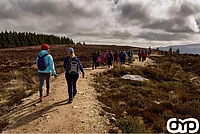
The Dublin Mountains Way (DMW) is a flagship project of the Dublin Mountains Partnership. It is a 42.6 km national way marked linear trail which crosses the Dublin mountains from Shankill in the east to Tallaght in the west and vice-versa. The establishment of the DMW had been an objective of the local authorities for close to twenty years and with the formation of the Dublin Mountains Partnership this ambition was realised. This project has been achieved through the cooperation of Coillte, Dún Laoghaire Rathdown County Council, South Dublin County Council, Dublin City Council and a number of private landowners. The Dublin Mountains Way was officially opened on the 31st of October 2010.
To take a preview of the route watch the Tracks & Trails series - Dublin Mountains Way episode with Ken Doherty and Fair City actress Ciara O'Callaghan.
Trail Classification
The DMW is classified, using Sport Ireland’s trail classification system, as a strenuous trail. A strenuous trail has moderately steep climbs for long sections (up to 20 mins). The going underfoot can be extremely rough and can include many obstacles.
The DMW route itself includes a mixture of surfaces, gravel trail, wooden board walk, forest floor and county road. The DMW route is generally suitable for people accustomed to walking rough trails who have a high level of fitness, typically all day or multi-day walkers. Specific outdoor walking footwear and clothing are required. The DMW can be broken up into shorter sections and walked over several days.
County Road Sections of the Dublin Mountains Way
Over 40% of the DMW is along County Roads, the majority of these road sections are relatively quiet and rural but there are very few sections with footpaths. Please see below an extract from the Road Safety Authority's Pedestrian safety - Road safety tips to help you walk safely on our roads:
'As a pedestrian, you are one of the most vulnerable road users. So it’s important that you practice good road safety and take personal responsibility in keeping yourself and others safe on our roads.
Walking safely beside or along a road, practice these road safety tips whenever you walk, take exercise or head out socially:
• If there is a footpath, you must use it.
• If there is no footpath, you must walk as near as possible to the right-hand side of the road, facing oncoming traffic.
• If the road is narrow or carries heavy traffic, you should walk in single file and never more than two abreast.
• You should always wear bright, high-visibility clothing when walking during the day and reflective clothing when walking at night.
• You should always carry a torch when walking at night.
• You should always be aware of other road users.
• If you are walking as a group of more than 20 people, you should walk on the left-hand side of the road, in the direction of traffic flow.
• You should never walk on the road after consuming alcohol as this is very dangerous at any time of day or night.'
For more information check out the RSA website and the Rules of the Road.
Maps & Brochure of the Dublin Mountains Way
You can down load a route map of the DMW here: DMW brochure, for a paper copy email your postal address to info@dublinmountains.ie, more detailed section maps are available below.
Trailhead Maps & Information
Please see link to a pdf of the Trailhead sign at Shankill, pictured below.
Please see link to a pdf of the Trailhead sign in Seán Walsh Park in Tallaght, , pictured below.
External Map Sources
Sport Ireland Outdoors: Dublin Mountains Way
Hiiker website and App: Dublin Mountains Way
East West Mapping: paper maps Dublin & North Wicklow Mountains (scale 1:30,000), digital map via app North Wicklow.
OSI: Discovery Series 50 (scale 1:50,000), Adventure Series: Wicklow North (scale 1:25,000).
DLR Tourism's Dublin Mountains Experience interactive map is another great resource.
Planning your Hike along the Dublin Mountains Way
At 42.6 km long and with more than 50% of the route off road if you are planning to do the DMW over one, two or three days you will need to plan what food and drink you are going to carry, consider where you will stop along the route, your transport connections and accommodation. In this section some information on transport options, pit stops and links to accommodation are provided.
Preparation for a Hike
Leave No Trace Ireland and Mountaineering Ireland both have excellent resources to help you plan a hike:
Hiking Checklist - Leave No Trace Ireland
Happy Hiking - Mountaineering Ireland
Getting to the start of the Dublin Mountains Way
The DMW was planned as a route that starts and ends close to the public transport hubs at Tallaght and Shankill. Tallaght is served by the LUAS Red Line and Dublin Bus Services. Shankill is served by the DART and Dublin Bus Services. Transport for Ireland's TFI Live App is an essential tool to plan your hike along the DMW. If you haven't used the App before it is worth taking some time to familiarise yourself with how it works especially if you are planning to do the DMW in sections. While there are public transport options at the start/end of the DMW there are only limited services thereafter.
Parking: at Shankill DART Station, 1km from the start of the DMW, there is a public car-park, the daily cost to park is €3. At Tallaght there are a number of fee paying parking options including at the Square Shopping Centre and Best Car-Parks.
Public Transport Connections along the Dublin Mountains Way
There are direct connections from the DMW to public transport at Barnaslingan (7 days a week), Glencullen (weekdays only), Tibradden (Saturdays only),Bohernabreena (Saturdays only), see details below.
Starting on Saturday 14th of September 2024 a new Local Link Bus route will operate on Saturdays, with four services in each direction between Tibradden Wood and Tallaght, also serving Cruagh Wood and Hell Fire Club.
If you are planning on using public transport do download the TFI Live App, familiarise yourself with how it works, the TFI website includes instructional videos. A top tip from the DMP is to save the bus stop numbers listed below as favourites on the TFI Live App.
Another way to explore multi-modal connections to the DMW, including taxis, is the Rome2Rio website.
Barnaslingan: Dublin Bus Route 44, link to Timetable. Bus Stop 4088, the Scalp Wood (direction Enniskerry) and Bus Stop 4121,the Scalp Wood (direction Dublin).
Glencullen: Dublin Bus Route 44b, link to Timetable. Bus Stop 3508 Johnnie Fox's, Glencullen.
Tibradden Wood: Local Link Kildare South Dublin Route SD4 Tallaght to Tibradden Wood, Saturday service.
Bohernabreena: Local Link Kildare South Dublin, Route SD03 Bohernabreena to Tallaght, link to timetable. Bus Stops at: Upper Reservoir Gate, Glenasmole Community Centre, Cunard, Head of Brakes, and Tallaght Luas Bus Stop 4348.
Pit-Stops Along the Dublin Mountains Way
Shankill and Tallaght- start/end
The DMW starts and ends in Shankill Village and Tallaght where there is a great range of shops, supermarkets, cafes, pubs and restaurants.
Glencullen Village (11.5 km from Shankill, 31km from Tallaght)
Johnnie Fox's pub, Ireland's highest pub and a tourist destination, open 7 days a week, and with an extensive menu.
Grizzlys Glencullen set in the grounds of the GAP (Glencullen Adventure Park), a mountain biking trail centre, has a lovely menu of small and big bites. Grizzlys Glencullen is open between Wednesday and Sunday (09:00 to 17:00) with late opening on Thursdays until 21:00. There are toilet facilities here.
Tibradden Wood (mid-way on the DMW)
Zipit operate a series of zip-line adventure courses at Tibradden Wood between February and late November. At their cabin they sell a range of hot and cold drinks, crisps and chocolate bars. Cross-check their daily opening times as they vary through the seasons.
Glenasmole Valley
Glenasmole Community Centre is open to the public for tea, coffee and refreshments Monday to Friday between 09:00 and 17:00. There are toilet facilities. The Community Centre is 9km from Tallaght and 33km from Shankill.
Accommodation
See links to accommodation listings on Local Authority Tourism Sites and local business websites
- Dublin’s Outdoors
- DLR Tourism
- Glencullen Adventure Park
- Wicklow Way website (Enniskerry is the closest location listed to the DMW)
- Johnnie Fox’s
- Tibradden Farm Cottages (note minimum stay is 4 nights)
Glencullen village is 11.5km from Shankill on the DMW, or 31km from Tallaght, if you are planning on walking mid-week, you could use the 44b bus which runs between Glencullen village and Dundrum, check the timetable as this is not a frequent service.
Camping - there are no designated camping locations along the DMW. Coillte do not allow wild camping on its land in the Dublin Mountains.
Livestock & the DMW
Walkers planning to walk the DMW should be aware that the DMW passes through lands where livestock may be present, please abide by safety and warning signage.
Dogs & the DMW
If you are planning to walk the DMW with your dog note that to protect wildlife and livestock from disturbance or injury all dogs must be kept on leads at all times, no exceptions.
Way-Marking
The DMW route is fully waymarked with the national waymarked route standard yellow hiker symbol. Two areas where extra attention needs to be paid are Two Rock Mountain between Tibradden Wood and Fairy Castle and in Barnaslingan Wood. On the western slopes of Two Rock Mountain the Dublin Mountains Way has a 1km overlap with the Wicklow Way, another national way marked route, through this section and the junctions leading to and away from this section way-marking plaques also have the text, 'Dublin Mountains Way' or 'Wicklow Way' as appropriate. Through Barnaslingan Wood a section of the DMW travels through a rocky old woodland with no defined path, you walk on the forest floor, in this area some of the yellow hiker way-markers are painted on trees.
Points of Interest Along the Dublin Mountains Way
Archaeology
The Dublin Mountains Way passes archaeological monuments at Tibradden, Fairy Castle and Ballyedmonduff, see links for more information.
Reporting Issues on the DMW
To report any issues along the trail or to request additional information please contact: info@dublinmountains.ie
Notice of minor detour at start/end of the DMW in Sean Walsh Park, Tallaght
From January 2023 until further notice there is a minor detour at the start/end of the Dublin Mountains Way in Sean Walsh Park to facilitate the completion of the building of age friendly housing.
Access to the Dublin Mountains Way is via a pedestrian gate on Whitestown Way leading into Sean Walsh Park, follow 'pedestrian access' signs.
Dublin Mountains Way Completion Badge
 |
A Dublin Mountains Way badge is awarded to people who complete the DMW, this is a lovely way to commemorate your achievement.
To receive a badge send an email with your postal address to info@dublinmountains.ie
DMW Trailhead sign in Sean Walsh Park

DMW Trailhead sign in Shankill

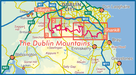

Click on the numbers on the map to view the individual maps for the Dublin Mountain Way or select for the list below.
To read the PDF files you need Adobe Reader installed. Adobe Reader is free software that lets you view and print Adobe Portable Document Format (PDF) files. If you do not have Adobe Reader on your computer, you can download it below.
MAP 1 Shankill - Barnaslingan
Travelling in a westerly direction, the trail starts on the main street in Shankill at a metal trailhead sign beside Brady's pub . The route brings the walker through a residential part of Shankill on a series of laneways before crossing the M11 motorway on a pedestrian bridge. The DMW route then travels on narrow County roads for 0.7km, it is advisable to wear high visibility vests for these road sections. What follows is a beautiful tree lined laneway which passes the beautiful Fassaroe Cross and leads into Rathmichael Wood named for the hill fort that dominates the summit. From Rathmichael Wood the route is along Pucks Castle Lane and onwards and upwards to Carrickgollogan Wood a mixed coniferous woodland with stunning views of Dublin Bay and the Wicklow Mountains, it is also known as the Lead Mines. From Carrickgollogan there is a short section of narrow County Road, Murphy's Lane, before entering Barnaslingan Wood also known as the Scalp Wood.
 |
 |
MAP 1 Barnaslingan - Fairy Castle/Three Rock
Leaving Barnaslingan Wood the route heads along the Enniskerry Road to the former Kilternan Sports Hotel where it turns west and travels through the grounds of the Hotel, past the Ski Slope, before emerging onto Killegar Lane, this is a new section as of April 2018. From here the DMW heads north to join Ballybetagh road and onwards to Glencullen village, please take care on this narrow section of County road. There is an option of a pit stop at the famous Johnnie Foxes pub in the village. From Glencullen Village the route travels a short distance on the Ballybrack Road before turning into the grounds of the GAP (Glencullen Adventure Park) where there is an option for another pit-stop at the GAP Kitchen (open Wednesday to Sunday). The DMW travels through this private land and private woodland before emerging into Coillte's Ballyedmonduff Forest. The DMW follows a forest road from Ballyedmonduff into Tiknock forest before climbing up to Fairy Castle, the highest point on the Dublin Mountains Way at 537m.
 |
MAP 2 Fairy Castle /Three Rock - Cruagh
Heading down from Fairy Castle the DMW joins the Wicklow Way for a 1km section. Be very mindful of junctions in this section as both routes are way-marked with a yellow hiker but do also have the route names in text on the way-marker plaque, i.e. Wicklow Way or Dublin Mountains Way. At a junction beside a Trail Head map board the DMW heads northwest towards Tibradden Mountain while the Wicklow Way travels south onto the Glencullen to Tibradden County road. The DMW travels across the open mountain passing Tibradden Cairn on the summit of Tibradden Mountain. This section of the trail was constructed in the autumn of 2008 with financial support from Comhairle na Tuaithe. It is over 2.5 km in length and offers walkers excellent walking on a robust trail constructed to best international practice (modified for Irish conditions) and has already become hugely popular with walkers. The DMW then travels downhill into Tibradden Wood also known as the Pine Forest and home to ZIPIT an exciting zip-line experience. The DMW crosses the Tibradden to Glencullen road into Cruagh Wood, be careful at this junction. The route through Cruagh is a lovely upwards pull for approximately 2km before levelling out and descending out onto the Cruagh Road.
 |
 |
MAP 2 Massy's Estate and Hellfire Club Optional Route
There is an option on exiting Cruagh Wood to cross the County Road into Massy's Estate and onwards to Hell Fire Club Forest, note this would be an 8-10km detour.
 |
MAP 2 Cruagh - Glenasmole
Leaving Cruagh wood the DMW heads up to the wonderful viewpoint at Killakee and along the Military Road before turning into Featherbed forest, be careful on this section of County road. There is a short walk through Featherbed forest along a purpose built trail. At the exit of Featherbed forest there are fantastic views towards the Wicklow Uplands and the summits of Kippure and Corrig Mountains. From Featherbed forest to the entrance to Glenasmole Reservoir it is a 6km journey on County roads. It is advisable to wear a high visibility vest for all County road sections. Along this route there are lovely views of the Glenasmole Valley home to the legend of Tír na nÓg. Look out for the dancing stone near Castlekelly Bridge.
MAP 3 Glenasmole - Tallaght
The DMW enters Dublin City Council's Glenasmole site, also known as Bohernabreena, for a beautiful 4km journey alongside the reservoirs which still supply drinking water to Dublin. From the exit of Bohernabreena the DMW crosses into South Dublin County Council's Kiltipper Park, if you look back along this short route through the Park there are stunning views of the Dublin Mountains. From Kiltipper Park there is a short section through residential areas before the DMW enters Sean Walsh Park, from here it is just over 1km to the end of the DMW marked by a trailhead map.
 |
- Recreation
- Archaeology
Recreation Sites in the Dublin Mountains
- 5. Kilmashogue
- 6. Ticknock
- 7. Carrickgollogan
- 8. Barnaslingan
Archaeology Sites in the Dublin Mountains
- 1. Slievethoul
- 2. Lugg Woods
- 3. Seahan
- 4. Hell Fire Club
- 5. Massy's Wood
- 6. Tibradden
- 7. Kilmashogue
- 8. Ticknock
- 9. Ballyedmonduff
- 10. Rathmichael Wood